
Hiking in Panama
Top 5 Hiking Trails in Boquete Panama
Nestled in a valley surrounded by mountains, cloud forest, lush jungle and volcano peaks….it is no wonder that Boquete is one of the most popular places for hiking in Panama. This region is known for its natural beauty and nothing is as wonderful as experiencing a place the way it was really meant to be experienced. The Volcan Baru National Park is home to big cats, monkeys of all kinds, the Resplendent Quetzal. Also, Jurassic-looking local flora… huge, lush and leafy ferns, and long vines with broad foliage. All of this and more awaits you, just a hop, skip and a jump from Boquete town. So, put on those hiking boots and let’s hit the dusty (er, probably muddy) trail!
Choosing the Right Path – Our Top Picks For Hiking in Boquete
There is no small number of hiking trails in Boquete, so choosing the right one (or 2, or 3) can be quite the vacation dilemma. Well, if you call having to choose between waterfalls, volcanoes, birding or cloud forest a dilemma that is. So we are here to help you find the best day hikes in Boquete based on your interests and skill levels. In this blog we are showcasing 5 of our most popular hikes in Boquete, each offering a little something unique of their own.
Pipeline Trail – A Hike The Whole Family Will Enjoy
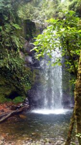
This is one of the most popular hiking trails in Panama’s Bajo Mano region. With even, steady terrain and a well-marked path, the Pipeline Trail is recommended for all ages and most physical abilities. The reward at the end is a 91m (300 ft) cascading waterfall. And the trail gets its name for the ever-present pipeline runs from the trailhead all the way to the waterfall.
Because the trail is so easy, it’s a great one for really studying and appreciating the surroundings. Bring your binoculars. You can expect to see all manner of wildlife and plant life too while traversing 2 different micro-climates. This is a popular trail to encounter the beautiful yet elusive Resplendent Quetzal among a ton of other birds that call the Boquete region home. Oh, and Armadillo’s are frequently spotted using the Pipeline Trail themselves.

Aside from the Waterfall and the chance of spotting a Quetzal, our favorite part of this trail is the giant tree. Depending on who you ask, the tree is somewhere between 1000 and 1500 years old. Straight out of Fern Gully. Talk about impressive!! Bring the whole family on this sweet, easy and beautiful trail.
Hike Length: 4.5 kilometers (2.8 miles)
Duration: Approx 3 hours
Type of Terrain: Easy to moderate hike on one well-defined path with very gradual incline
Highlights: 91 meter high waterfall, Quetzal nesting, and majestically gigantic tree
Best For: Groups of varying abilities and fitness levels. Our top choice for families.
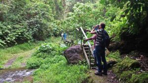
Sendero Culebra Trail – Birding The Cloud Forest
The name means “Snake Trail” but it is so named because of the bends and curves, like a slithery snake’s body. This trail is often best described as damp, muddy and mossy. Big leafy jungle ferns abound, and you’ll find orchids, liverworts, huge trees, and interesting local flora anywhere your eyes roam.
The entire Sendero Culebra trail actually takes you all the way to Bocas Del Toro and is a multi-day hike for more experienced hikers only. Obviously not one you should do alone, and we can think of much easier ways to reach Bocas Del Toro from Boquete. In fact, now that these indigenous trails have been replaced by buses or shuttles, they are no longer well-maintained and the chances of getting lost in the forest is a serious threat.
However there is a short and sweet version of this hike that takes you to the heart of the cloud forest in just a few hours. That is what we recommend for those just looking for a day hike in Boquete. The day hike is only about 3.2 km (2 miles) round trip and is another easy to moderate hike for all skill levels. Sendero Culebra is more mystical cloud forest and a haven for birders than the Pipeline Trail.
Hike Length: Day hike 3 to 7 kilometers (2 to 4.5 miles) / Full hike 40km (24 miles)
Duration: Day hike approx. 2.5 to 4 hours / Full hike….a few days
Type of Terrain: Day hike easy to moderate hiking through a narrow trail through the cloud forest. Full hike… steep! There’s 1,200 feet of elevation gain on this one. Not for the faint of heart. You would need to be an experienced hiker in excellent physical condition.
Highlights: Birding, wildlife spotting and Boquete cloud forest at its best
Best For: Birders, naturalists and those with moderate to good physical condition
Lost Waterfalls Trail – Photographers’ Dream Hike
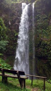
This very popular Boquete hiking trail takes you to not just one, but 3 amazing waterfalls! It is also a photographers dream as there are so many “natural frame” opportunities…aka Instagram heaven folks. The Lost Waterfalls Trail is probably one of our favorite Boquete hikes. However, the Lost Waterfalls hike is a bit more strenuous than the Pipeline and Sendera Culebra half day hikes. Thus, this is not the most recommended hike for everyone, but most definitely those in good physical condition who don’t mind a bit of mud and rocky terrain.
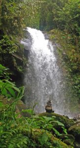
There are a total of 3 waterfalls you can visit, with the 3rd being the most difficult to get to. One option could be to skip that last big push if some in your group are not up for it, then you’d just have a moderate hike the whole way. The Lost Waterfalls hike is just a short distance from Boquete town, but the earthiness, hanging vines and thick jungle foliage will make you feel like you’re worlds away. The trail is one big loop, and the first waterfall is just 10-15 minutes in. It’s a rocky but well-defined trail, and there will be a good bit of climbing if you’re to reach that 3rd waterfall.
Hike Length: 4.5 kilometers (2.8 miles)
Duration: Approx 3 hours
Type of Terrain: Rocky climb, can be muddy, well defined but tricky trail at times due to the muddy terrain. Moderate to challenging hike.
Highlights: 3 different waterfalls! Also the opportunity to find howler monkeys, sloths, multiple bird species and maybe even a tapir.
Best For: Photographers or Influencers in good physical condition looking for that perfect Instagram or Facebook post.
Sendero Los Quetzales – Central America’s Shining Star, The Quetzal Trail
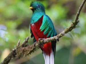
Located within the Volcan Baru National Park, the Quetzal Trail is touted as one of the most beautiful hikes in Central America. Just the name invokes an in depth history of the importance of Quetzales in the history of Central America. Aside from being an important part of the Mayan, Aztec and Inca cultures, the Quetzal bird is a stunning species to witness first hand.This hike rewards you with some beautiful views at the top, but to get there you’ll have to work for it, so expect a big push at one point… with big stairs too… but an awesome workout and even more awesome scenery in all directions.
The Quetzal trail is another one of the Boquete hiking trails that can be a long challenging hike, or can be shortened to a short, yet still challenging hike. The challenge depends if you are going from Boquete to Cerro Punta, or vice versa. Boquete to Cerro Punta is a much more challenging uphill climb. From Cerro Punta to Boquete it is mostly downhill…but then there is that knee thing as you are trying to descend. Thus, the Quetzal trail hike is a bit more challenging than the previous hikes we experienced.
The best Boquete day hike on the Quetzal Trail starts on the Cerro Punta side. Not only is it a downhill hike, you also reach the famed Quetzals breeding grounds earlier in the journey. Since Cerro Punta is a bit far, a guided hike is most definitely the way to go. Quetzales prefer cooler climates at higher altitudes. Since Cerro Punta is about 2500 meters above sea level, and the trailhead in Boquete is at about 1800 meters, your chance of running into Quetzales in the first half of your hike greatly increases.
Hike Length: Day hike 7km (4.34 mi) Full Hike kilometers (14.2 miles)
Duration: Day hike approx 4 to 5 hours / Full hike 8 hours
Type of Terrain: Looking for a consistent and somewhat challenging trail? This is the one you want. If you’re in good physical condition, the Quetzal trail is a great choice! Oh yeah, and did we mention the stairs? Be prepared.
Highlights: Aside from the famed Quetzales, this is a truly amazing hiking trail in Boquete. “Mirador La Roca” is certainly an amazing viewpoint worth trekking to.
Best For: Birding enthusiasts & hikers in good physical condition looking for a bit of a challenge
Volcan Baru Summit Hike – Quest to the Top Of The Highest Peak In Panama
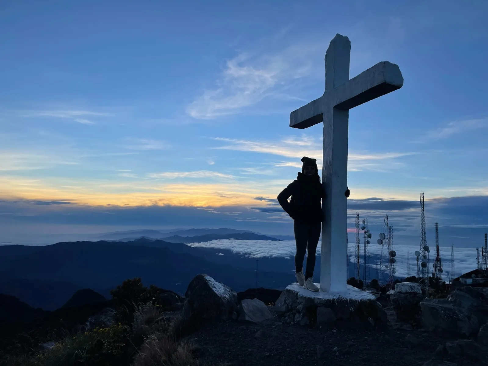
The Volcano Baru trail is the granddaddy of hiking in Boquete by far and way. It’s the highest peak in Panama, but surprisingly close to Boquete. The best experience possible is to leave at around 11 pm in the evening to make the 6 hour trek to the peak for sunrise. Talk about spectacular photo ops. On a good day you can view both the Pacific and Atalantic sides of Panama. Then you have to climb back down. Needless to say, this is the most challenging hike in Boquete. It is also one of the most rewarding!
Many folks set out on this hike in the middle of the night so they reach the summit as the sun rises. As crazy as that might sound, this is actually one of the most popular Boquete hiking tours. Expect 6,000+ feet of elevation gain, and plan accordingly! The terrain is rocky, and that makes it a bit more challenging. Visibility is great from that high up; you’ll be able to see the Boquete city lights from some vantage points, and storms off in the distance too. The view from the top is Bucket list worthy, but you’ll have to really climb to get all the way there. You’ll want something warm when you reach the top… a hat and gloves. Bring your camera… whatever you do, don’t forget your camera!!
Hike Length: 26 kilometers (16 miles)
Duration: 8 to 11 hours
Type of Terrain: Steep with loose rock. Extremely challenging
Highlights: A seriously amazing view of both the Pacific and Atlantic coasts, an amazing sunrise, and the memory of a lifetime achievement.
Best For: Serious hikers and those looking to check climbing a mountain summit off their bucket list
As you can see, hiking trails in Boquete Panama can vary quite a lot! From long and difficult to easy and breezy, there is a wide range of hikes available to suit a wide range of interests and abilities. What are you planning to do with your holiday in Panama? The Boquete hiking trails add something extra wonderful to your vacation experience. And with Boquete always right nearby, it’s a lovely getaway without getting too far “out there”.
Most of Panama’s hiking trails were originally established by the indigenous cultures. In Boquete specifically, the trails were carved out to get to point A to point B, not as a leisurely activity we now enjoy. With the evolution of transportation, the once very well-maintained hiking trails in Panama have been pushed aside. This means the trails, unless used for touristic purposes, are not nearly as well-used as they once were. Which also means, that it is easier to get lost in the jungle since the paths are not clearly marked. This has led to more than one incidents of lost hikers in Panama in recent years.
For this reason, we highly recommend booking a guided hike in Boquete. Some trails such as the Pipeline are relatively easy to access on your own, however going with a local guide has many more benefits. First of all, do you know what birds you are hearing? Can you find them hidden in the trees? Probably not, but your guide sure does. What about the unmarked forks in the trail? Yup, your guide has been hiking in Boquete for years. No need to worry where you are going. How do you reach the trailhead? No worries when your guide picks you up and ensures you get safely back to your hostel or hotel. Sure guided tours cost a bit more, but they are SOOOOOOOO worth it.
Not convinced you should go with a guide? Search trip advisor reviews and compare the difference between someone’s experience with a guide, and another’s on their own. The cautionary tales are very….telling.
So this is just a list of our Top 5 Favorite Boquete Hiking Tours, but there are several more day hikes in Panama we can help you with as well. Below is a quick reference guide to some of the most visited hiking trails in Boquete.
Most Popular Boquete Hiking Trails |
|||
| Boquete Day Hikes | Approximate Distance | Average Duration | Activity Level |
| El Retoño (Short hike in Amistad National Park) | 3.2 km / 2 mi | 2.5 to 3 hrs | Easy (Flat hike in Parque National de Amistad bordering Costa Rica) |
| Snake Trail 1/2 Day Hike (Sendero Culebra) | 3.2 km / 2 mi | 2.5 to 3 hrs | Easy to Moderate (Anyone in decent physical condition) |
| White Rock (Peña Blanca Hike) | 4.5 km / 2.8 mi | 3 to 4 hrs | Easy (Fairly flat hike good for all levels) |
| Pipeline Trail | 4.5 km / 2.8 mi | 3 hrs | Easy to Moderate ( Fairly flat with a climb at the end) |
| Amistad National Park Waterfall Hike (La Cascada en el Parque Internacional La Amistad) | 3.4 km / 2.2 mi | 3 hrs | Moderate (2 km Uphill then slippery steep terrain near the waterfall) |
| Lino Rock (Piedra de Lino Hike) | 4 km / 2.5 mi | 3.5 to 4.5 hrs | Moderate (Short but more strenuous uphill climb) |
| The Fortress (La Artilleria Hike) | 5 km / 3.1 mi | 3 to 4 hrs | Moderate (Great views, slightly strenuous uphill climb) |
| Lady of the Mountain ( La Novia de la Montaña) | 4 km / 2.5 mi | 3 to 4 hrs | Moderate (Rotating flat and then steep climbs on uneven terrain) |
| The Piano Player (La Pianista) Day Hike | 5 km / 3.1 mi | 4 to 5 hrs | Moderate (Medium level climb but poorly marked trails) |
| The Lost Waterfalls Trail ( 3 Cascadas Perdidas) | 4.5 km / 2.8 mi | 3 hrs | Moderate to Challenging (Slippery uneven trails, steep climbs) |
| The Quetzal Trail Day Hike (Sendero de los Quetzales) | 7 km/ 4.34 mi | 5+ hrs | Moderate to Challenging (Steep downhill or uphill depending starting point) |
| The Volcano Baru Summit Trail ( Volcan Baru | 26 km / 16 mi | 10 to 12 hrs | Challenging (Steep uphill and downhill, endurance climb to the summit) |
If you are interested in hiking on of the other trails listed that we do not offer daily, let us know and we can try to set you up with a local guide.